As some background, the Waterfront Toronto is the agency that gets government funding to revitalize our city's waterfront. It's been doing its work since 2001 and you can see its stamp pretty clearly on Queens Quay (HTO Park, Spadina Wavedeck are just two examples).
The organization has been looking at improving the central waterfront area, we can maybe call it from Bay Street to Spadina corridor.
You can read a lot more about the revitalization of the Queens Quay area on their website. Specifically, you can read a useful December 2008 presentation on the redevelopment of the road in this huge but very readable PDF.
In short, the project is looking to achieve some guiding principles: Better balance between traffic and pedestrians, provide a world-class transit system, development "context sensitive approach to design", use all of the transit area to improve the public realm, creating a value added space, making the waterfront a destination, and supporting community and businesses.
Here are some of the options
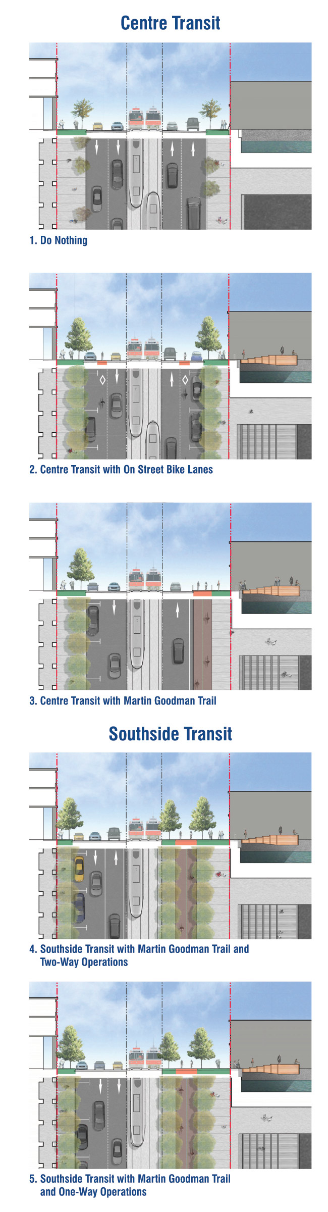 Option 1: Do nothing, pretty straightforward but it probably wouldn't meet most of the principles mentioned above. As a QQ resident, we think that going forward with nothing it not the worst thing that could happens, but there seems to be a huge divide of ... well, concrete, between the north and south side. Note that option 1 doesn't include the Wavedeck, which is already in the process of being built.
Option 2: Centre transit with on street bike lanes. You can see the difference already and that is that vehicle traffic would be hit. There would be on street parking and in addition, bike lanes, which would mean that both east and west bound traffic would be limited to one lane. You can see that on busy days, the traffic would really down to a crawl, but for cyclists, that would definitely help navigate an area with tonnes of buses and parked cars.
Option 3: Centre transit with Martin Goodman Trail. This would see parking on the north side and reduced to one land on both north and southbound. Bringing the Martin Goodman on to Queens Quay would be huge for the trail, as it loses its identity between Bathurst and Jarvis, a boon to both runners, cyclists and pedestrians.
Option 4: South transit with MGT and two-way operation: So, expanded Martin Goodman Trail plus more greenery, the whole south side of the streetcars would be pedestrian/cyclists. The north would be two way.
Option 5: South transit with MGT and one-way operation: Like No. 4 but with westbound only traffic.
Tomorrow, the three finalists

No comments:
Post a Comment
If you enjoyed this post, please leave a comment or subscribe to our RSS feed. Email tips to queensquaylife@gmail.com We're also looking for contributors so please email us if you're interested.